The mention of Alaska has always conjured up visions of gold. Early gold-seekers traveled to Alaska by every means imaginable and endured endless hardships. They stayed to build communities in the wilderness. Present-day travelers, still lured by gold, come to Alaska to try their hand at panning or sluicing on the streams of the last frontier. They search for elusive gold nuggets or other semi-precious minerals.
The Dalton Highway
Built in 1974 to transport materials to oilfields on the North Slope, the Dalton Highway slices through northern Alaska, paralleling the Trans-Alaska Pipeline from Livengood to Prudhoe Bay. The BLM manages public land on both sides of the highway from the Yukon River to Mile 301. The state manages the land from there to Prudhoe Bay. The Dalton Highway is a gravel road that can be very rough, dusty or slippery, depending on weather. If stopping, pull as far to the right as you safely can. Do not block the gates on pipeline access roads. Off-highway vehicle use is prohibited within five miles of the highway.
Carry emergency equipment, such as a CB radio, blankets or sleeping bags, spare tires, standard tools and first-aid equipment. Gas, restaurant food, lodging, phone, tire repair, and emergency towing are available at Yukon Crossing (summer only) Coldfoot, and Deadhorse. No other public services are available along the Dalton Highway.
Recreational Mineral Collection
Some BLM-managed public lands along the Dalton Highway south of Atigun Pass are open to recreational mineral collection. The BLM has inventoried and rated these streams for their mineral potential. The ratings are listed on the map below.
Areas closed to recreational mineral collection include the pipeline right-of-way (27 feet on either side of the pipeline) and land legally claimed for mining or other purposes. You should stay at least 100 feet away from the pipeline to ensure you don't encroach on the right-of-way. To collect minerals on a private mining claim, you must obtain permission from the claimant. Check with the BLM's Public Information Center in Fairbanks (474-2251) to determine the claimant's name and address. The removal of placer gold on navigable waterways is regulated by the State of Alaska. For further information, contact the Department of Natural Resources at (907) 451-2705.
Equipment
You can use a pick, shovel, rocker and sluice box, and metal detector. Motorized equipment is not allowed. Suction dredging is prohibited within the Utility Corridor (the BLM-managed public lands surrounding the Dalton Highway) without prior authorization. Authorization can only be given for suction dredging on existing federal mining claims.
Historic and Prehistoric Sites
The 1906 Antiquities Act prohibits the removal, excavation or destruction of any historic or prehistoric ruin or monument, or any object of historic value located on federal land. Please notify the BLM if
you find any items protected by the Antiquities Act.
Maps
For accurate locations obtain the following inch-to-the-mile maps from U.S. Geological Survey. 1:63,360 quads: Bettles C-2, D-1, D-2 Wiseman A-1, B-1 Chandalar B-6, C-6
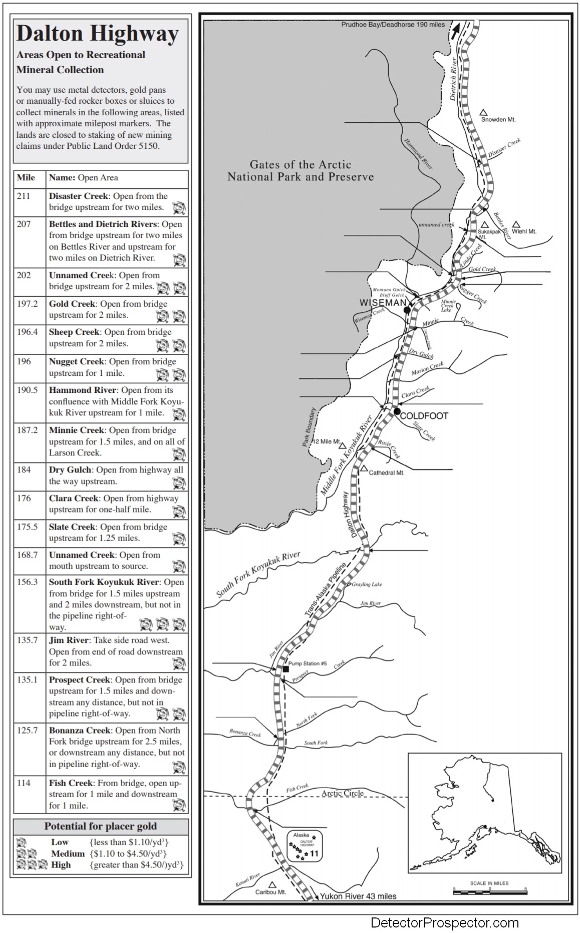
Dalton Highway Gold Panning Sites - Click image for larger version
The use of any motorized vehicle off the highway is prohibited within 5 miles on either side of the Dalton Highway without prior written authorization. This prohibition does not apply to off-road vehicles necessary for oil and gas exploration, development, production, or transportation or to a person who holds a mining claim in the vicinity of the highway, and who must use land within five miles of the right-of-way of the highway to gain access to their mining claim.
Camping
Marion Creek Campground, approximately five miles north of Coldfoot, is the only developed public campground along the Dalton Highway. It has both pull-through and tent sites, as well as outhouses and a water well. Each site has a picnic table and either a grill or a fire ring. This BLM federal fee site is open June through mid-September. Golden Age and Golden Access Passport holders pay half price. Campground hosts live on site. Travelers may also camp on gravel bars along rivers and in some pull-off areas left from old pipeline camps. Arctic soils and vegetation are easily damaged and take a long time to heal, so please practice “leave no trace” camping. Recreational camping is limited to 14 days at any one spot.
Here is a list of parking areas, access points, and facilities. In general, be aware that facilities are few and far between on the Dalton Highway. Bring everything with you that you may need, including tools and spare tires. See the BLM Dalton Highway Visitor Guide 2017 for more information.
|
Mile |
Agency |
Location |
Description |
|
105.8 |
AF&G |
Kanuti River |
Small parking area and concrete boat launch to Kanuti River on east side of road. |
|
115 |
BLM |
Arctic Circle Wayside |
Site is complete with a wayside, picnic tables, grills, restroom facilities, interpretive displays, and a campground. |
|
132 |
BLM |
Gobblers Knob |
Wayside-Parking, toilet and scenic view. |
|
135 |
DOT(P) |
Prospect Creek |
Day use campground area with restroom facilities and a boat launch area. Interpretation is planned. |
|
136 |
BLM |
Jim River |
Parking and river access. |
|
150 |
DOT(P) |
Grayling Lake |
A small turnout was identified as a potential site for interpretation of the archeology of the area. |
|
156 |
BLM |
South Fork Koyukuk River |
Parking, unimproved boat launch at river crossing within highway ROW. |
|
161 |
DOT(P) |
Chapman Lake |
Views of Brooks Range. Identified for improvements including a picnic area, restrooms, parking, and trails. |
|
175-180 |
BLM |
Coldfoot/ Marion Creek Campground |
Amenities include a visitor center, restrooms, parking, campgrounds, and trailheads. Plans exist for interpretation. |
|
186 |
DOT(P) |
Scenic Overlook |
Offers views of community of Wiseman and Koyukuk River. Interpretation about community and mining history possible. |
|
188.5 |
DOT(P) |
Middle Fork Koyukuk Bridge #1 |
Bridge No.1 with turnout. Dolly Varden, grayling, whitefish. |
|
197 |
DOT(P) |
Gold Creek Trailhead |
Established trails exist in area, parking and trailhead development at this site would improve access to the back country. |
|
204-207 |
BLM |
Sukapak Mountain Overlook |
Small pull off could be expanded. The BLM has identified two potential sites for photo and interpretive opportunities. |
|
207 |
DOT(P) |
Dietrich River Bridge |
Turnout to west at south end; burbot, grayling, whitefish and Dolly Varden. |
|
211 |
DOT(P) |
Disaster Creek |
Served as a checkpoint during the development of the pipeline, interpretive opportunities exist, no scenic views. |
|
235 |
DOT(P) |
Last Tree |
This site has been identified by the BLM as an interpretive site. Parking exists close by. |
For more information contact:
U. S. Department of the Interior
Bureau of Land Management
Northern Field Office
1150 University Avenue
Fairbanks, Alaska 99709-3844
(907) 474-2200
Related BLM publications:
Birds along the Dalton Highway
Dalton Highway Visitors Guide
Bear Facts
Current road conditions:
Department of Transportation Recording: (907) 456-7623
Traveler's Advisory Radio: 1610 AM
(originating at Fox, Alaska)
Visitor information is available at:
• Yukon Crossing Visitor Contact Station, Mile 56. Open Memorial Day to August 31 from 9 a.m. to 6 p.m., no phone.
• Arctic Interagency Visitor Center, Mile 175. Open Memorial Day to Labor Day, 10 a.m. to 10 p.m., phone (907) 678-5209, fax (907) 678-2005.
BLM Dalton Highway Visitor Guide 2017
Dalton Highway Corridor Management Area
Source: The above is derived from the BLM brochure Dalton Highway - Areas Open to Recreational Mineral Collection.
-
 1
1
-
 1
1